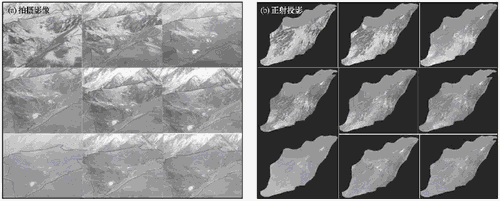
Spatial and temporal distribution of snow cover is complicated and greatly affected by topography, land cover, radiation and snow drifting. Snow cover information with high spatial and temporal resolution is hard to obtain by in-situ measurements or satellite image. In this paper, a small watershed of Hulugou River was selected as a conventional photography experiment field. It was tried to use photos by using photogrammetry to obtain spatial distribution information of snow cover through orthographic Projection system. It was found that between the measured and the calculated projection centers there was a difference ΔX of -9.27~25.51 m, a difference ΔY of -33.53~18.2 m and a difference ΔZ of -3.33~9 m. Error analysis of single snow cover map shows that the differences in X, Y and Z are -9.27~25.51 m, -33.53~18.2 m and -3.33~9 m, respectively. Further analyses indicate that the precision of snow cover mapping depends on precision of DEM, photographic distance and photographic angle. However, with the improvement of basic topographic data, snow cover map derived from photogrammetry will be advanced.

Snowmelt process photos(a) and their orthographic projection maps(b) in a small watershed
Download from the attachment

