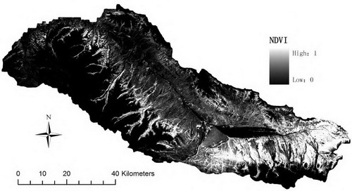
The Shule River Basin, which is situated in the northeast edge of the Qinghai-Xizang Plateau, has the typical continental arid desert climate.
This research retrieved the fractional vegetation cover of alpine grassland in the source region of the Shule River Basin based on Chinese environmental satellite (HJ-1A/1B) images and field data, and analyzed the response of the vegetation cover to topographic factors and types of frozen ground.
The results showed that the vegetation coverage of this region was low with large spatial heterogeneity and high degree of dispersion. The landscape consisted mainly of non-vegetation surface types, eg. Ice, snow, the bare rock gravel land and bare land. Slopes and aspects were the main limiting factors of vegetation distribution.
The average vegetation coverage decreased with the increase of slope. The average vegetation coverage was the lowest on the sunny slope, and the highest on the shady slope.
There were significant differences of vegetation coverage among different types of frozen ground. The distribution of vegetation coverage presented a reversed “U” curve trend by extreme stable permafrost, stable permafrost, sub-stable permafrost, transition permafrost, unstable permafrost and seasonal frost, and the average vegetation coverage was the highest in the sub-stable permafrost.
This research is financially supported by the National Basic Research Program of China (No. 2013CBA01807), the National Natural Science Foundation of China (No. 41271089), and the Strategy Leading S&T Project of CAS (No. XDB030303), and the Public Welfare Industry (Meteorological) Special Scientific Research Projects (No. GYHY201306017).
This paper has been published on the Chinese Journal of Applied Ecology.

Fig.1 Locations of the field observation in the study area

