Beiluhe basin is underlain by warm and ice-rich permafrost, and covered by vegetation and soils characteristic of the Qinghai-Tibet Plateau. A field monitoring network was established to investigate permafrost conditions and to assess potential impacts of local factors and climate change.
This paper describes the spatial variations in permafrost conditions from instrumented boreholes, controlling environmental factors, and recent thermal evolution of permafrost in the basin. The study area was divided into 10 ecotypes using satellite imagery based classification.
The field investigations and cluster analysis of ground temperatures indicated that permafrost underlies most of the ground in swamp meadow, undisturbed alpine meadow, degrading alpine meadow, and desert alpine grassland, but is absent in other cover types.
Permafrost-ecotope relations examined over a 2-year (2014–2016) period indicated that: (i) ground surface temperatures varied largely among ecotopes; (ii) annual mean ground temperatures ranged from − 1.5 to 0 °C in permafrost, indicating sensitive permafrost conditions; (iii) active-layer thicknesses ranged from 1.4 m to 3.4 m; (iv) ground ice content at the top of permafrost is high, but the active-layer soil is relatively dry.
Long-term climate warming has driven thermal changes to permafrost, but ground surface characteristics and soil moisture content strongly influence the ground thermal state. These factors control local-scale spatial variations in permafrost conditions.
The warm permafrost in the basin is commonly in thermal disequilibrium, and is sensitive to future climate change. Active-layer thicknesses have increased by at least 42 cm and the mean annual ground temperatures have increased by up to 0.2 °C in the past 10 years over the basin. A permafrost distribution map was produced based on ecotypes, suggesting that permafrost underlies 64% of the study region.
This research achievement is published on Science of The Total Environment.
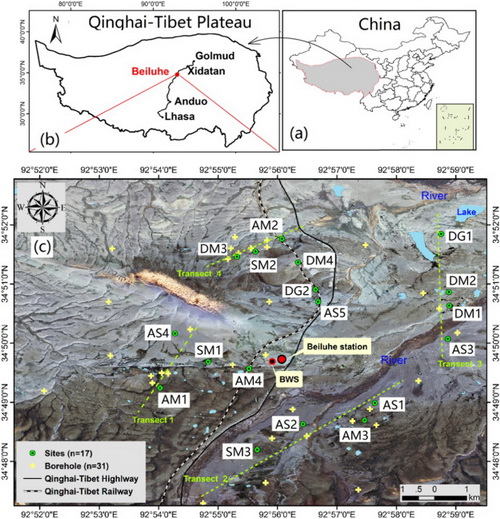
Fig. Maps of China (a) and location of the study area on the Qinghai-Tibet Plateau (b) and the distribution of field sites in the Beiluhe basin (c). BWS – Beiluhe Weather Station. Beiluhe station - Beiluhe Observation Station of Frozen Soil Environment and Engineering. Green circles indicate ground temperature measurement sites with temperature loggers. The yellow crosses are boreholes without temperature loggers. The map (c) is based on a GF-1 image from October 1, 2014. (Image by NIU Fujun)