As the second largest inland river in China, the Heihe River Basin, located in the semi-arid and arid regions of northwest China, is a very important water resource for irrigated agricultural areas in the Hexi Corridor of Gansu province. Therefore, it is very necessary to monitor spatiotemporal variations in water use in irrigated fields with high spatial resolution data and facilitate water resources management and irrigation scheduling in such a water shortage area.
Evapotranspiration (ET), the sum of land surface evaporation and plant transpiration, is a major component of the water cycle and energy exchange of the soil-vegetation-atmosphere system that affects the redistribution of terrestrial surface radiation and precipitation.
It is essential for water management nationwide at the field scale to map daily ET over irrigated agricultural areas in the heihe River Basin at a high spatiotemporal resolution using thermal remote sensing-based models. However, it is difficult to map temporally continuous daily ET at a high spatial resolution due to the current lack of high spatiotemporal resolution remote sensing data.
To achieve a continuous spatial distribution of daily ET with a high spatial resolution, a research group headed by HUANG Chunlin from Heihe Remote Sensing Experimental Research Station, Key Laboratory of Remote Sensing of Gansu Province, Northwest Institute of Eco-Environment and Resources of Chinese Academy of Sciences has mapped daily ET over irrigated agricultural areas in the Heihe River Basin of northwest China based on spatiotemporal fusion of the Advanced Space-borne Thermal Emission Reflectance Radiometer (ASTER) and Moderate Resolution Imaging Spectroradiometer (MODIS) images.
Researchers collected the high spatial resolution data by using various kinds of sensors and analyzed the spatiotemporal characteristics of these data, and compared the time series of daily ET modelled from the Surface Energy Balance System (SEBS) with that modelled from PT-JPL (one of Satellite-based Priestley-Taylor ET model) and observations from eddy covariance (EC) systems.
The research results indicate that regional ET mapping at a high spatiotemporal resolution can be accurately achieved based on the Spatial and Temporal Adaptive Reflectance Fusion Model (STARFM) and Surface Energy Balance System (SEBS). The method of mapping daily ET at a high spatiotemporal resolution proposed in this study can be applied to long-term series, large research areas, and other satellite images for further verification of its applicability in future studies.
The results have been published in the journal Agricultural and Forest Meteorology in an article entitled “Mapping daily evapotranspiration based on spatiotemporal fusion of ASTER and MODIS images over irrigated agricultural areas in the Heihe River Basin, Northwest China.”
This work is supported by the National Science Foundation of China under Grants 91425303 and 41671375, and the Science and Technology Service Network Initiative Project of the Chinese Academy of Sciences.
Contact:
HUANG Chunlin
E-mail: huangcl@lzb.ac.cn
Key Laboratory of Remote Sensing of Gansu Province, Heihe Remote Sensing Experimental Research Station, Northwest Institute of Eco-Environment and Resources, Chinese Academy of Sciences, Lanzhou, 730000, China.
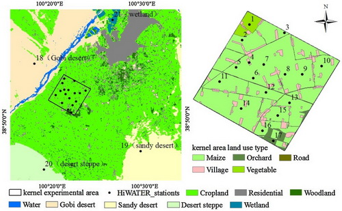
Land use map of the study area and the location of AWS/EC stations (Image by HUANG Chunlin)